| Translate This News In |
|---|
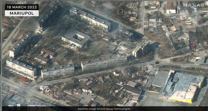
The latest satellite imagery shows the extent of destruction in Ukrainian cities targeted by Russian airstrikes and artillery as the pro-Western country’s conflict enters its fourth week.
The images released by Maxar Technologies, a private US company, show significant damage to residential homes, apartment buildings, and stores in Mariupol, Ukraine’s port city on the front lines of the war. New airstrikes and artillery impacts have also been observed in and around Kyiv. Damage to supermarkets, homes, apartment areas, and other infrastructural facilities can be seen in Hostel, Moschun, Irpin, and other towns to the northwest of the city. Irpin, a frontline suburb of Kyiv, has seen some of the bloodiest fightings since Russia invaded Ukraine.
Russia’s offensive is largely stalled, with troops located about 30 kilometers (20 miles) east of the capital and encountering stiff resistance.
The images show that Russian forces are increasingly using earthen revetments (berms) to protect/conceal their armored equipment deployments near Antonov Airport in Hostomel, as well as other locations in and around Zdvyzhivka and Berestyanka.
Moscow has been accused of committing war crimes by deliberately shelling residential areas, according to Kyiv. According to officials, 2,500 people have died since Russian forces crossed the Ukrainian border on February 24.
Ukraine President Volodymyr Zelensky called on Saturday for meaningful talks with Russia to end its invasion of Ukraine, warning that if Moscow does not reverse course, it will take “several generations” to recover from battlefield losses.


